Persistent dengue transmission in tropical cities reflects a complex interplay between environmental microclimates and urban housing structure that supports Aedes mosquito breeding. This study applies drone-based microhabitat risk mapping integrated with a biologically defined Composite Risk Index (CRI) to quantify fine-scale environmental drivers of Aedes habitat risk across distinct residential typologies in Sect.” 24, Shah Alam, Malaysia. High-resolution RGB imagery obtained using a DJI Phantom 4 Pro was processed to derive the Brightness Index (BI) as a proxy for shade intensity and the Excess Green Index (ExG) as an indicator of vegetation density. These indices were integrated a priori into a CRI to operationalise known ecological conditions favourable for Aedes. Spatial analysis revealed a consistent risk gradient, with terrace housing exhibiting higher Composite Risk Index (CRI) values than flat complexes (low-density terrace (Teres D) > dense terrace (Teres B) > medium-rise (Flat H) > high-rise (Flat B)), demonstrating that housing typology modulates the spatial expression of microhabitat risk rather than vegetation presence alone. Model calibration showed high predictive agreement (R? = 0.91), with the top 20% of CRI-ranked pixels capturing 65% of observed breeding-prone zones, indicating strong spatial discriminative performance. These findings highlight that vegetation’shade coupling, expressed through housing morphology, governs Aedes habitat persistence and that drone-based microclimate mapping provides a precision surveillance tool for spatially targeted dengue control.
Dengue fever remains one of the most rapidly expanding mosquito-borne diseases in the world, with over 400 million infections estimated annually across more than 120 countries1,2. In Malaysia, dengue has evolved from a cyclical outbreak to a persistent public health threat, driven by rapid urbanization, environmental degradation, and the proliferation of Aedes aegypti and Aedes albopictus3,4,5. Despite decades of vector control efforts, the disease continues to intensify in urban and suburban areas where human habitation, built environment, and vegetation coexist in complex spatial arrangements. Traditional entomological surveillance methods reliant on larval indices and manual inspection are often constrained by labor, cost, and temporal coverage, leaving significant gaps in identifying and targeting high-risk micro-environments6.
Recent advances in drone-based remote sensing and geospatial analytics offer new opportunities to address these limitations7. High-resolution unmanned aerial vehicle (UAV) imagery allows fine-scale mapping of environmental features that influence vector ecology, including vegetation structure, shade intensity, and surface moisture proxies8,9. These parameters collectively shape the microclimatic conditions that determine the survival, reproduction, and dispersal of Aedes mosquitoes10,11. Unlike conventional satellite imagery, which lacks the spatial resolution needed to capture neighborhood-scale heterogeneity, drone-based data acquisition provides centimeter-level precision suitable for detecting potential breeding habitats embedded within residential areas12. Integrating spectral and brightness indices from drone imagery thus enables a more comprehensive and quantifiable understanding of how urban morphology drives vector risk13,14. In tropical cities such as Shah Alam, Malaysia, Aedes breeding persists even in well-maintained neighborhoods, suggesting that micro-environmental factors particularly shade’vegetation interactions play a stronger role than previously assumed15,16. Vegetation retains humidity and organic matter essential for larval development, while shade stabilizes temperature and prolongs water availability in artificial containers17. However, few studies have quantitatively examined how these factors interact spatially across contrasting urban housing types18. Most existing studies have relied on coarse land-use classifications or limited ground surveys, which overlook the fine-scale environmental gradients that sustain mosquito populations19,20. There remains a critical need to characterize the micro-scale environmental configurations that favor Aedes survival, particularly in settings where vegetation and architectural shade overlap to form humid, stable microhabitats.
This study addresses this gap by applying a drone-based environmental modeling framework to quantify the spatial coupling between vegetation and shade across multiple residential morphologies in Sect.” 24, Shah Alam. Using high-resolution RGB orthomosaics, three environmental indices were derived: the Brightness Index (BI) to represent shade intensity, the Excess Green Index (ExG) to measure vegetation density, and a Composite Risk Index (CRI) integrating both variables to delineate Aedes-prone microhabitats. These indices were analyzed across four representative housing typologies; high-rise, medium-rise, dense terrace, and low-density terrace to evaluate how built-form characteristics shape local breeding risk. By integrating drone photogrammetry, GIS-based spatial modeling, and ground validation, this study provides a novel fine-scale assessment of environmental risk patterns linked to Aedes ecology. It seeks to answer a fundamental question: how do micro-environmental configurations of shade and vegetation interact to create and sustain mosquito breeding sites within urban residential settings” The findings aim to bridge entomological surveillance and environmental modeling, offering a reproducible framework for precision vector control and evidence-based dengue prevention aligned with Malaysia’s Integrated Vector Management (IVM) strategy and the Sustainable Development Goals.
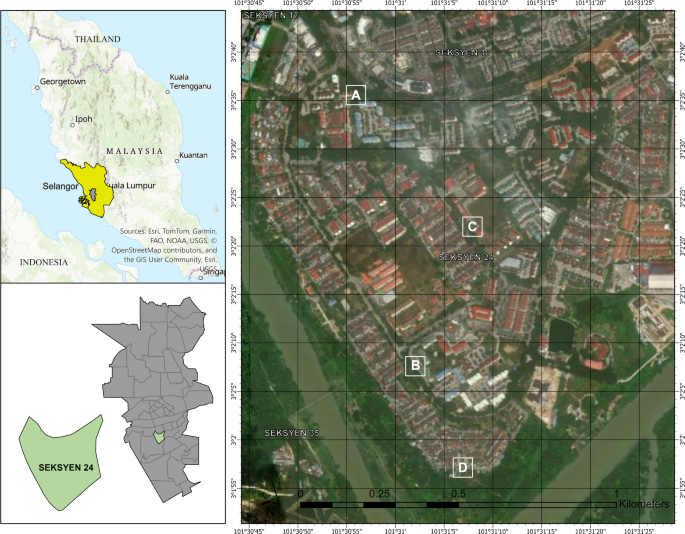
The study was conducted in Shah Alam, Selangor, Malaysia (3.069’N, 101.518’E), located approximately 25 km southwest of Kuala Lumpur within the Klang Valley conurbation (Fig. 1). Selangor is Malaysia’s most urbanized and dengue-endemic state, with a warm and humid equatorial climate that supports year-round mosquito breeding. The area experiences mean daily temperatures between 26 “C and 32 “C and an annual rainfall exceeding 2,400 mm, creating ideal environmental conditions for Aedes mosquito proliferation. Section 24 was selected due to its heterogeneous urban morphology and recurring dengue notifications recorded by the Shah Alam City Council21.
As illustrated in Fig.”1, the study area comprises four distinct residential typologies: Flat B (high-rise complex, A), Flat H (medium-rise block, B), Teres B (dense terrace housing, C), and Teres D (low-density terrace housing, D). These zones represent varying gradients of built form, vegetation cover, and shading, enabling assessment of how micro-environmental factors influence Aedes habitat risk. The flat complexes are dominated by multi-storey buildings with extensive impervious surfaces, minimal green spaces, and narrow perimeter corridors that generate transient shaded micro-sites but limited organic substrate. In contrast, the terrace zones contain a mixture of single- and double-storey houses surrounded by gardens, boundary hedges, and rear-yard vegetation clusters that trap humidity and reduce solar exposure. Teres D comprises extensive vegetated patches within and around residential parcels, providing a contrasting landscape context for subsequent ExG-based vegetation quantification.
Published on 2/14/2026